Some of the most information-rich data mashups (including Propublica’s Tools & Data blog, BBC’s Datablog, Trulia’s crime map, and the Bay Citizen‘s bike accident app) show off robust mapping tools well within the grasp of hacks and hackers alike. The visualization above, powered by datasf.org and Google’s Fusion Tables, shows just how easy it is to mashup metadata and locations using Google’s geocoding engine.
Among the rich troves available from DataSF, an interesting record capturing shot locations and movie minutiae gathered by the SF Film Commission provides an interesting gateway to the city’s cinematic past. Before deeper analysis, a few threshold data cleansing issues should be addressed:
- A simple CONCATENATE operator to append “San Francisco, CA” to sparse address information is all that’s needed for Google to situate each record.
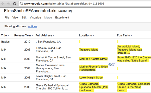
- Next, upload the full table (including movie titles, actors, and facts) and plot it on a Google Map using Fusion Tables. (The actual steps, import and visualize, are pretty self-explanatory. Start off here: http://www.google.com/fusiontables/Home.) This dataset imports fairly cleanly; for less structured corpuses, Google Refine is indispensable.
The real fun comes with the numerous display and filtering options available. (See http://www.google.com/fusiontables/DataSource?dsrcid=1151606.) After visualizing the full dataset, goto the View > Filter options and limit the display to specific actors, a single movie, or a release year date range. Integrate the results with data from additional tables, say a MUNI bus route map, and roll your own Star Map for publication on your website. The chart view below provides a handy summarize or “count()” function for histograms.
Thanks to the Bay Citizen (specifically, @tinio for the Fusion Table demo), SF Hacks Hackers, and DataSF for the weekend of #datasf presentations and knowledge sharing.
Related articles
- Google Refine Gets Fusion Tables Import and More (readwriteweb.com)
- Geo APIs Summer Learning Series: Managing and visualizing your location based data with Fusion Tables (googlegeodevelopers.blogspot.com)
- Fusing Film Facts with Google Maps (geoffnet.com)
